
Walk a Champaign Street by Address
A useful Champaign street directory search follows the records in the order their keys connect. An address leads to a parcel identification number, or PIN. The PIN then joins the tax card, map, deed history, and legal description. A voter lookup works differently: Illinois requires a known person's name, birth date, ZIP code, street number, and street name. It cannot be used to browse a whole block. Historical street sections may add a dated occupant, but they do not prove who lives there now.
- Confirm the address with the City address query and note whether it falls inside Champaign city limits.
- Search the County Property Tax Inquiry by house number, street name, street type, and city. Save the PIN and situs address.
- Open the same PIN in CCGISC Public GIS. Check parcel boundaries, subdivision context, address layers, and adjoining geometry.
- Run the PIN through Recorded Deed History, then open the linked instrument route when the index alone is not enough.
- For older occupants, consult year-specific street sections and scans held by the Urbana Free Library and UIUC.
This chain separates current ownership, mapped location, recorded transfers, and past occupancy. Those are related facts, but they are not interchangeable.
Search Champaign Parcel Fields
The Champaign County Property Tax Inquiry has Parcel Search, Advanced Parcel Search, and Mobile Home Search. Ordinary real estate can be found by address or PIN, but the inspected form did not offer a broad owner-name field. Mobile homes have a separate owner-name control. This makes the portal an address tool, not a general directory of Champaign residents.
| Search field | Format | Use in a street search |
|---|---|---|
| Parcel number | With or without dashes | Direct key to one parcel |
| House, street, type, city | Text and suffix | Finds the situs by address |
| Sale date and price | Ranges | Narrows indexed sales |
| Township, district, class | Advanced choices | Filters the tax roll |
| Tax year low/high | Year range | Checks older parcel cards |
The portal recommends the PIN shown on a tax bill when it is known. For rural roads, its parsing guidance places the road number in the street field. Common suffixes are shortened, so a second attempt with Av, Ct, Dr, Ln, Rd, or St may solve a failed search.
The manifest source for the sample parcel card shows how many kinds of facts sit behind one result.
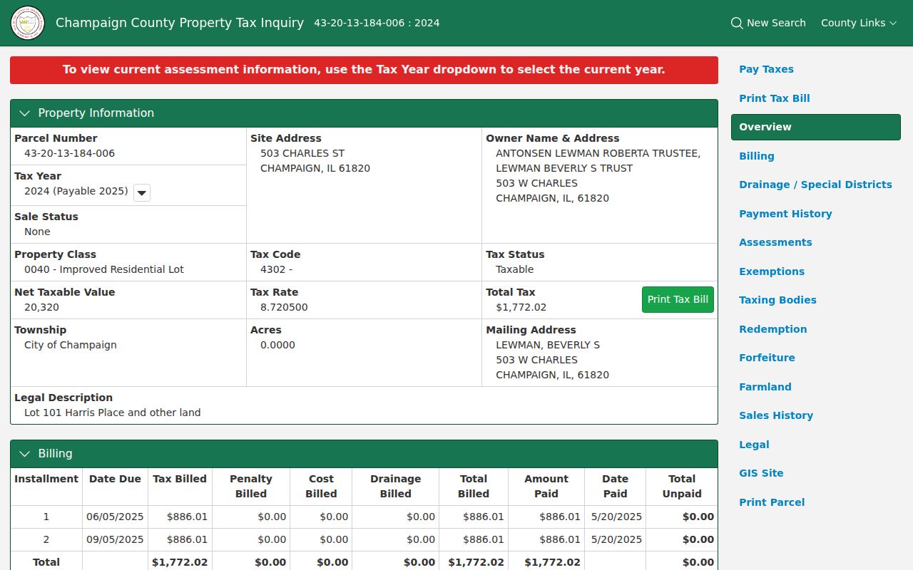
The capture is a field example, not proof of current occupancy. It demonstrates why tax year and capture date belong in every saved citation.
Champaign Records Keyed by Street
No single Champaign street directory contains every owner and occupant. The strongest approach compares address-keyed sources and keeps each source's limit visible.
| Source | Address key | Person-linked result | Main limit |
|---|---|---|---|
| City address points | Complete or subaddress | Parcel link and flags | No household roster |
| County tax card | House, street, city, or PIN | Owner and tax mailing line | Owner may not occupy site |
| CCGISC GIS | PIN, address, intersection | Parcel and map context | General index, not survey |
| Recorded deeds | PIN or legal description | Indexed grantor and grantee | Index may omit parties |
| City permits | Address or permit number | Contacts and chronology | Split between two portals |
| Historic directories | Street and name sections | Dated occupant entry | Publication cutoff applies |
The parcel number is the most stable join. It links the tax card to deeds and mapped boundaries even when a street is abbreviated or an older source uses a different style.
Which Champaign Address Is It?
CCGISC keeps tax mailing and site-location data in separate layers. A mailing address tells the county where tax mail goes. A situs address means the physical location of the parcel. One parcel can contain several main building addresses and several units, while a one-to-one layer selects just one main address for systems that demand one row. That choice can be administrative, not proof that one household occupies the parcel.
- Parcel
- A mapped tract tied to a PIN and tax record.
- Situs address
- The physical location assigned to property, unlike a tax mailing address.
- Plat
- A recorded map of lots, blocks, subdivisions, or boundaries.
- Criss-cross directory
- A publication arranged by street or address rather than only by surname.
Champaign's city address service also records subaddresses, ZIP+4, anomaly status, addressing authority, and parcel number. Record the exact layer used. A “residential” or “mailable” flag describes the address point, not a named resident.
Note: One CCGISC example places three main building addresses and five units on one parcel, so one parcel never guarantees one household.
Map Champaign Streets in CCGISC
The CCGISC Public GIS accepts PIN, address, leasehold, and intersection searches. Its documented tools include parcel pop-ups, layers, measurement, map extent, subdivision or taxpayer queries, an attribute table, printing, and historic aerial context. The separate Address/Street Query can find street segments, select addresses inside a drawn shape, and apply a buffer. A buffer is simply a measured zone around a map feature.
Start with one verified parcel, then inspect touching polygons and their pop-ups. Save the map date, layer name, and spatial relation. CCGISC calls the public map a general index and warns that it is not a legal survey. Parcel adjacency proves only that mapped shapes touch or sit near one another.
For a reproducible address result, print or save the selected extent with a title and legend. Historic tax maps cover archived revision years from 1980 through 2007, while the interactive atlas begins with revision year 2008. Historic plats cited by the county FAQ include 1970 and 1976.
Follow Champaign Deeds by PIN
The CCGISC Recorded Deed History Search takes a PIN and can sort by document number, recorded date, or document type. Its warning matters: results may be incomplete, and one shown grantor or grantee may stand for a deed with more parties. The index then links to Tapestry, where an image or extended access may cost money.
The source for the deed-history capture shows the PIN-only starting point and its result-order controls.
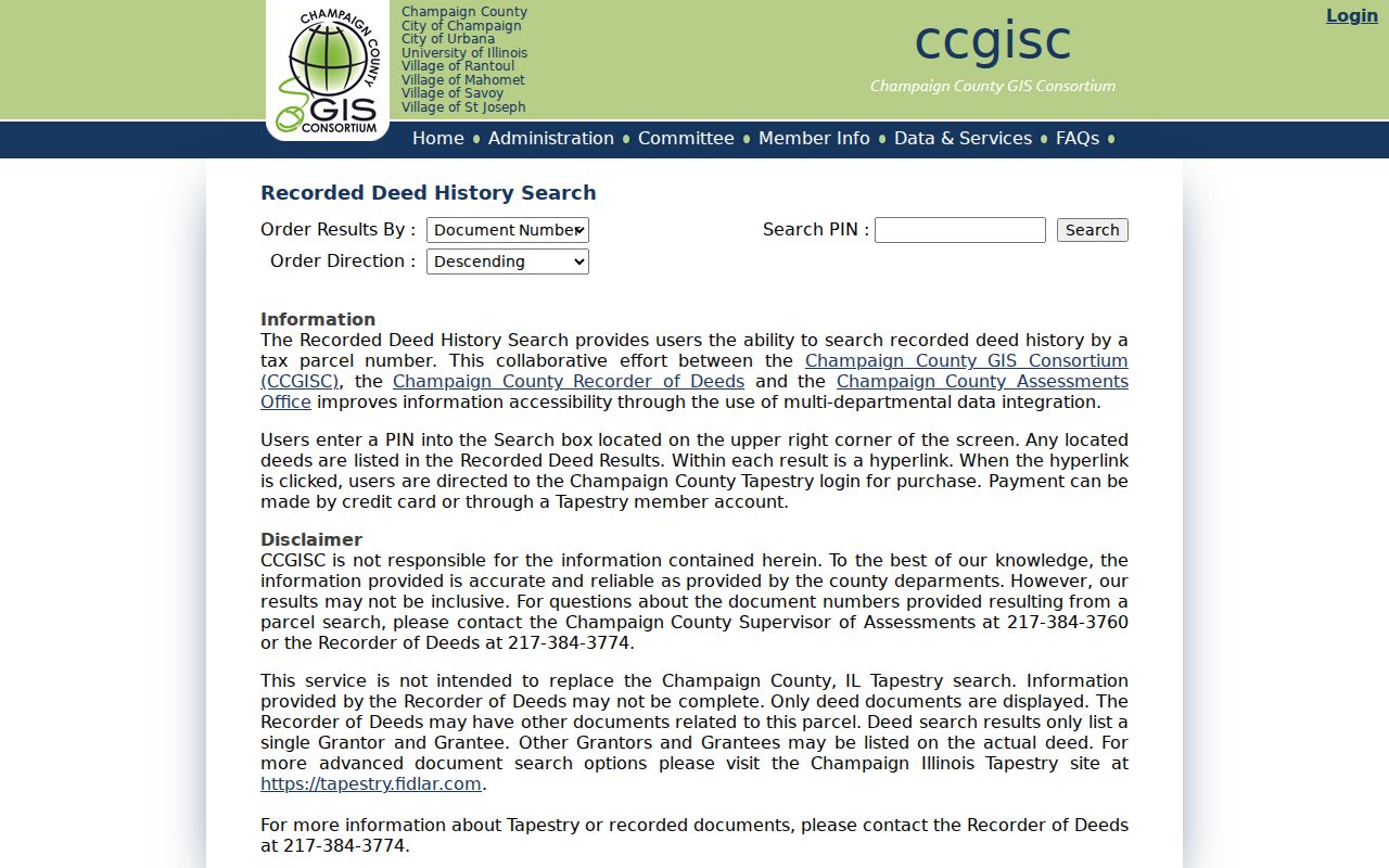
The screen makes the limit plain: the street address must first be resolved to a PIN before this branch of the Champaign street directory can work.
For deeper searching, Tapestry's official instructions document names, document number and type, date range, consideration, subdivision, lot, block, parcel, and metes-and-bounds fields. A legal description identifies land by lot, block, subdivision, or measured boundaries and can survive a change in street numbering.
The manifest source for the Tapestry search capture displays those non-member controls.
Use the broader fields only to resolve a known parcel or transaction. Save the instrument number and obtain the record image when the index row does not settle the chain.
Champaign Permits Split at 2025
Address history now crosses two City Building Safety systems. eTRAKiT covers permits issued on or before December 31, 2024. It searches address, permit number, description, type, status, value, and issue dates, with operators such as begins, contains, and equals. Result tabs can show contacts, inspections, conditions, reviews, and chronology.
OpenGov handles permits on or after January 1, 2025. That recent switch means one portal cannot answer a long property question. Search both sides of the date line, and treat a permit contact as tied to that permit, not as proof of residence.
Read Older Champaign Streets Carefully
Older Champaign directories may preserve directionals, suffixes, rural routes, telephone exchanges, and street sections that do not match a modern search string. Normalize W and West or St and Street for searching, but keep the printed form in notes. No official complete Champaign renumbering log was located, so a changed number must be tested against plats, deeds, aerials, and dated maps rather than guessed.
The Urbana Free Library archives and UIUC scans provide the historical shelf. A separately titled, complete criss-cross run was not confirmed, though street sections in city directories can serve as partial address indexes. The Champaign city directory collections have the year-by-year detail.
Verify Champaign Street Results Offline
Some address questions require a custodian, not another map layer. The Champaign County Clerk and Recorder records deeds, mortgages, releases, liens, plats, surveys, and subdivisions. The current county departments page lists the office at 102 E Main Street, Urbana, with the Recorder at 217-384-3774. Older IRAD material still shows the Brookens Administrative Center at 1776 E Washington Street. Call before a visit because both are official references from different periods.
The Assessment Office and CCGISC are also listed at 102 E Main Street. Assessment staff maintain parcel and mailing data, while CCGISC handles address and map systems. Ask for the record by PIN, legal description, instrument number, or exact street address. A precise key is more useful than a broad request for everyone on a road. For old deeds, the Illinois Regional Archives Depository inventory provides a deed index for 1833 through 1927 and deed records for 1833 through 1902.
The Illinois voter registration lookup is a confirmation tool for one person. It requires first and last name, birth date, five-digit ZIP, street number, and a street name selected by the form. It does not return a street-wide list. State computerized voter data is purpose-restricted and redacts sensitive fields, so it cannot fill the gaps in public address research.
When city permit portals, map tools, or published indexes do not contain a needed municipal record, the City of Champaign FOIA route accepts written requests by its listed mail, email, and in-person channels. Describe an address, record type, and date range. Illinois FOIA does not override sealed, confidential, or otherwise protected material.
Limits of a Champaign Street Directory
A parcel card identifies an owner or tax contact, not each occupant. A deed documents a transfer, not who slept at the address on a later date. GIS shows mapped relationships, not friendships or family ties. Illinois voter lookup requires facts about one known voter and does not expose a block roster. Utility customer lists and DMV address data are not ordinary public street-directory sources. Protected addresses and confidential records stay outside the chain.
Lawful use. Use Champaign address records for focused personal research, property history, or civic questions. Never use them to stalk, harass, threaten, or track a person.
When a portal does not answer the question, contact the custodian rather than forcing an inference. The Champaign County Clerk and Recorder handles recorded instruments at 102 E Main Street in Urbana, while CCGISC and the Assessment Office handle parcel and map questions. Official historical pages sometimes show the former Brookens address, so confirm the current office location before visiting.